


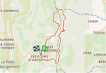
Jura_Plans d'Hotonne_Crêt du Nu

m261212
User

Length
16.4 km

Max alt
1351 m

Uphill gradient
471 m
Km-Effort
23 km

Min alt
1033 m

Downhill gradient
470 m
Boucle
Yes
Creation date :
2020-06-20 07:31:21.651
Updated on :
2020-06-21 19:28:11.56
5h45
Difficulty : Medium

FREE GPS app for hiking
 SityTrail
IGN / Geographical institutes
SityTrail Plus
The world is yours!
About
Trail Walking of 16.4 km to be discovered at Auvergne-Rhône-Alpes, Ain, Haut Valromey. This trail is proposed by m261212.
Positioning
Country:
France
Region :
Auvergne-Rhône-Alpes
Department/Province :
Ain
Municipality :
Haut Valromey
Location:
Hotonnes
Start:(Dec)
Start:(UTM)
709106 ; 5101957 (31T) N.
Comments